
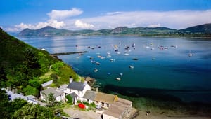


Walking on Anglesey

Anglesey has approximately 125 miles of coastline, providing walkers with many beautiful beaches and coastal paths to enjoy. 95% of the coastline of Anglesey can be walked by following the Coastal Path which takes you right around Anglesey, taking you through 36 villages and past half of the 80 churches on Anglesey. This route offers walks suitable for people of any ability and is sure to provide a breathtaking experience for anyone.
1. Holyhead to Church Bay
The start point of the walk is at St. Cybi’s Church in Holyhead. After the town, the Path passes through Penrhos Coastal Park over the embankment to Valley. The Path is attractive and low-lying with views back towards the port. There is now a new route around the Alaw estuary so there is no need to break there as instructed in some of the literature, however the estuary near the footbridge can be flooded at high tide, so check the tide tables.
2. Church Bay to Cemaes
The Path here includes some of the island’s most remote scenery and much of the coastline is National Trust. Rocky coves merge into steep cliffs that twist and fold all the way to Carmel Head, passing a sea arch and island at Ynys y Fydlyn. A section from here is closed in the shooting season, but there is an alternative inland route. A nature reserve is crossed at Cemlyn before reaching Wylfa Nuclear Power Station. The section ends at the pretty, little village of Cemaes.
3. Cemaes to Amlwch
This offers one of the most visually stunning sections of the Coastal Path. Leaving Cemaes, the Path immediately joins the rocky cliff-tops and takes you on a dizzying journey past Llanbadrig church, Porth Llanlleiana and Porth Cynfor to arrive at the spectacular bay of Porthwen. Low, rocky cliffs follow, leading into Amlwch Port. Here, near the watchtower you can look at a fascinating geological ‘clock’.
4. Amlwch to Moelfre
Leaving Amlwch Port along gentle heather clad terrain you could be forgiven for thinking this section of the Coastal Path is going to be easy on the legs. Once past Point Lynas, the landscape changes, taking in steep terrain with fine views eastwards. This diverse and often remote section of Path is characterised by the sandy expanses of Dulas estuary, Traeth yr Ora and Lligwy.
5. Moelfre to Pentraeth
This section of the Path, although short, offers a great variety of walking.
Starting from the attractive village of Moelfre, the Path takes a low level route to
Traeth Bychan. From here, you are treated to a dramatic series of limestone cliffs, yet you are still sheltered by a thick hedge along much of the cliff edge. On reaching Benllech, the Path continues just above sea level around the western edge of Red Wharf Bay.
6. Red Wharf Bay to Beaumaris
This section of the Path probably feels the longest, as it involves a significant amount of shoreline walking.
You begin at sea level, taking in the eastern half of Red Wharf Bay before joining the top of a sea wall for a 500-metre stretch.
There is currently a diversion along country lanes, owing to a landslip but it is hoped that there will be a new route shortly.
Climbing up towards Bwrdd Arthur, you will perhaps wish that you were walking in an anti-clockwise direction, but the views through farmland to Penmon Point are an ample reward. The latter half of the walk follows the shore along a tidal route with fine views of the Carneddau mountains across the Menai Strait.
7. Beaumaris to Llanfairpwll
Despite being largely road-bound, this section of the Path is enjoyable because of its attractive, elevated views along the narrowest section of the Menai Strait. The route passes under the historic Menai Suspension Bridge. The Wales Coast Path joins here. The route follows the Strait to the Britannia Bridge. It heads up and under the bridge before going down to St Mary’s Church, through the churchyard and along the shore to the hamlet of Pwllfanogl. There is now a detour inland around Plas Newydd so that the Path is complete with no gaps.
8. Llanfairpwll to Moel Y Don (Dwyran)
This is the flattest section of the Coastal Path and mainly keeps to the Menai Strait.
The landscape here is attractive; wooded farmland adjoins the shore and the mountains of Snowdonia and Caernarfon Castle provide a backdrop across the water.
You end the walk by heading inland to cross the Afon Braint over a memorable set of large stepping stones but beware they are covered at high tide and it is a long way round by Dwyran.
9. Newborough to Aberffraw
This section of the Path takes you through a National Nature Reserve where you can enjoy dunes, conifer forest and huge expanses of beach leading to the romantic island at Llanddwyn.
The remainder of the walk is a mixture of farmland and dunes, ending by joining the Ffraw estuary into Aberffraw itself. Snowdonia and the Lleyn Peninsula provide a powerful backdrop to the walk.
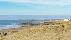
10. Aberffraw to Rhosneigr
This section of the Path highlights some of the island’s best sandy beaches.
The Path follows low rocky cliffs as far as the burial chamber of Barclodiad y Gawres at Cable Bay (Porth Trecastell).
From here, huge expanses of beach backed by dunes stretch all the way to the Inland Sea beyond Rhosneigr.
11. Rhosneigr to Treaddur Bay
From Rhosneigr the Path follows the shore, joining low-lying farmland to Four Mile Bridge where it crosses to Holy Island. The Path then heads slightly inland and through woodland.
After this, it closely follows a diverse stretch of coastline with rocky inlets, intermittent sandy coves and a series of striking cliffs in unusual colours.
You will pass the sea arches of ‘Bwa Gwyn’ and ‘Bwa Du’ before reaching a more developed section of coastline into Trearddur Bay.
12. Treaddur Bay to Holyhead
The island’s highest point is reached on this last section of the Path.
Once past the sandy bays of Trearddur, Porth y Post and Porth Dafarch you come to heather-clad coastline and towering cliffs as you journey on towards South Stack lighthouse and Holyhead Mountain. The mountain itself gives stunning views in all directions, allowing you to take in just how far you have walked, before heading down to the finish near the Port in Holyhead.
As the official start point of the Path is St. Cybi’s Church, the map for this section also covers the first section to Valley.


")
")
")
")
")
")
")
")
")
")
")
")
")
")
")
")
")
")
")
")
")
")
")
")
")
")
")
")
")
")
")
")
")
")
")
")
")
")
")
")
")


